![](/images/other/stat-length.png)
![Tocht Stappen Sorges et Ligueux en Périgord - Sorges et Ligueux en Périgord - Photo](https://media.geolcdn.com/t/1900/400/9d9cbeb0-19ad-4023-981e-3a56196224ce.jpg&format=pjpeg&maxdim=2)
Sorges et Ligueux en Périgord
NICOLEROBERT
Gebruiker
![Lengte](/images/other/stat-length.png)
Lengte
8,9 km
![Max. hoogte](https://static1.geolcdn.com/siteimages/upload/files/1508320355ic_sort_altitude_max_24dp.png)
Max. hoogte
191 m
![Positief hoogteverschil](https://static1.geolcdn.com/siteimages/upload/files/1508320355ic_sort_den_pos_24dp.png)
Positief hoogteverschil
105 m
![Km-Effort](/images/other/stat-length.png)
Km-Effort
10,4 km
![Min. hoogte](https://static1.geolcdn.com/siteimages/upload/files/1508320355ic_sort_altitude_min_24dp.png)
Min. hoogte
140 m
![Negatief hoogteverschil](https://static1.geolcdn.com/siteimages/upload/files/1508320355ic_sort_den_neg_24dp.png)
Negatief hoogteverschil
115 m
![Boucle](https://static1.geolcdn.com/siteimages/upload/files/16400158638029165_repeat_loop_refresh_sync_direction_icon.png)
Boucle
Ja
Datum van aanmaak :
2022-11-10 07:51:52.738
Laatste wijziging :
2022-11-10 10:26:19.552
![Stappen](https://static1.geolcdn.com/sitytour/trail-icons/101.png)
2h25
Moeilijkheid : Medium
![Scan deze QR-code om de tocht te openen in de SityTrail-applicatie](https://capi.geolives.com/qq0zvz2zws4bq2lad0pu/sitytour/trails/3451815/qr.png?size=200)
Gratisgps-wandelapplicatie
Over ons
Tocht Stappen van 8,9 km beschikbaar op Nieuw-Aquitanië, Dordogne, Sorges et Ligueux en Périgord. Deze tocht wordt voorgesteld door NICOLEROBERT.
Beschrijving
Boucle en partant du parc Valentine Bussiere lieu dit les Potences
Plaatsbepaling
Land:
France
Regio :
Nieuw-Aquitanië
Departement/Provincie :
Dordogne
Gemeente :
Sorges et Ligueux en Périgord
Locatie:
Unknown
Vertrek:(Dec)
Vertrek:(UTM)
329529 ; 5014380 (31T) N.
Opmerkingen
Wandeltochten in de omgeving
![Tocht Stappen Antonne-et-Trigonant - Lanmary variente 1 - Photo](https://media.geolcdn.com/t/375/260/401f1b0e-efaf-4088-b5dc-ed2841cc4d88.jpg&format=jpg&maxdim=2)
![Stappen Stappen](https://static1.geolcdn.com/sitytour/trail-icons/101.png)
Lanmary variente 1
Stappen
Medium
(1)
Antonne-et-Trigonant,
Nieuw-Aquitanië,
Dordogne,
France
![](/images/other/stat-length.png)
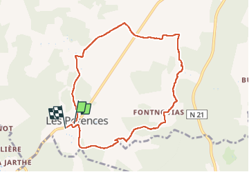
8,4 km | 10,4 km-effort
2h 52min
![](https://static1.geolcdn.com/siteimages/upload/files/16400158638029165_repeat_loop_refresh_sync_direction_icon.png)
Ja
![Tocht Stappen Sorges et Ligueux en Périgord - Sorges Causses et sous bois 10 km - Photo](https://media.geolcdn.com/t/375/260/ext.jpg?maxdim=2&url=https%3A%2F%2Fstatic1.geolcdn.com%2Fsiteimages%2Fupload%2Ffiles%2F1553511878bg_sport_marche.png)
![Stappen Stappen](https://static1.geolcdn.com/sitytour/trail-icons/101.png)
Sorges Causses et sous bois 10 km
Stappen
Gemakkelijk
(1)
Sorges et Ligueux en Périgord,
Nieuw-Aquitanië,
Dordogne,
France
![](/images/other/stat-length.png)
9,9 km | 12,6 km-effort
1h 49min
![](https://static1.geolcdn.com/siteimages/upload/files/16400158638029165_repeat_loop_refresh_sync_direction_icon.png)
Ja
![Tocht Stappen Sorges et Ligueux en Périgord - Sorges Téléthon 2013 11km - Photo](https://media.geolcdn.com/t/375/260/ext.jpg?maxdim=2&url=https%3A%2F%2Fstatic1.geolcdn.com%2Fsiteimages%2Fupload%2Ffiles%2F1553511878bg_sport_marche.png)
![Stappen Stappen](https://static1.geolcdn.com/sitytour/trail-icons/101.png)
Sorges Téléthon 2013 11km
Stappen
Gemakkelijk
(1)
Sorges et Ligueux en Périgord,
Nieuw-Aquitanië,
Dordogne,
France
![](/images/other/stat-length.png)
11 km | 13,2 km-effort
2h 57min
![](https://static1.geolcdn.com/siteimages/upload/files/16400158638029165_repeat_loop_refresh_sync_direction_icon.png)
Ja
![Tocht Stappen Sorges et Ligueux en Périgord - De Sorges à Perigueux sur la voie de Compostelle - Photo](https://media.geolcdn.com/t/375/260/4aaf4236-90c5-474d-8de9-7f6175f80c96.jpeg&format=jpg&maxdim=2)
![Stappen Stappen](https://static1.geolcdn.com/sitytour/trail-icons/101.png)
De Sorges à Perigueux sur la voie de Compostelle
Stappen
Zeer moeilijk
Sorges et Ligueux en Périgord,
Nieuw-Aquitanië,
Dordogne,
France
![](/images/other/stat-length.png)
25 km | 31 km-effort
5h 26min
![](https://static1.geolcdn.com/siteimages/upload/files/16400158638029165_repeat_loop_refresh_sync_direction_icon.png)
Neen
![Tocht Noords wandelen Antonne-et-Trigonant - Lanmary Sibaudie à l'envers - Photo](https://media.geolcdn.com/t/375/260/ext.jpg?maxdim=2&url=https%3A%2F%2Fstatic1.geolcdn.com%2Fsiteimages%2Fupload%2Ffiles%2F1545311037marcheuse_200dpi.jpg)
![Noords wandelen Noords wandelen](https://static1.geolcdn.com/sitytour/trail-icons/102.png)
Lanmary Sibaudie à l'envers
Noords wandelen
Heel gemakkelijk
(2)
Antonne-et-Trigonant,
Nieuw-Aquitanië,
Dordogne,
France
![](/images/other/stat-length.png)
11,8 km | 15,1 km-effort
2h 51min
![](https://static1.geolcdn.com/siteimages/upload/files/16400158638029165_repeat_loop_refresh_sync_direction_icon.png)
Ja
![Tocht Noords wandelen Antonne-et-Trigonant - Lanmary 8,7 km - Photo](https://media.geolcdn.com/t/375/260/ext.jpg?maxdim=2&url=https%3A%2F%2Fstatic1.geolcdn.com%2Fsiteimages%2Fupload%2Ffiles%2F1545311037marcheuse_200dpi.jpg)
![Noords wandelen Noords wandelen](https://static1.geolcdn.com/sitytour/trail-icons/102.png)
Lanmary 8,7 km
Noords wandelen
Gemakkelijk
(1)
Antonne-et-Trigonant,
Nieuw-Aquitanië,
Dordogne,
France
![](/images/other/stat-length.png)
8,7 km | 10,5 km-effort
1h 58min
![](https://static1.geolcdn.com/siteimages/upload/files/16400158638029165_repeat_loop_refresh_sync_direction_icon.png)
Ja
![Tocht Noords wandelen Antonne-et-Trigonant - lanmary 9.7 - Photo](https://media.geolcdn.com/t/375/260/ext.jpg?maxdim=2&url=https%3A%2F%2Fstatic1.geolcdn.com%2Fsiteimages%2Fupload%2Ffiles%2F1545311037marcheuse_200dpi.jpg)
![Noords wandelen Noords wandelen](https://static1.geolcdn.com/sitytour/trail-icons/102.png)
lanmary 9.7
Noords wandelen
Heel gemakkelijk
(1)
Antonne-et-Trigonant,
Nieuw-Aquitanië,
Dordogne,
France
![](/images/other/stat-length.png)
9,8 km | 12,2 km-effort
2h 13min
![](https://static1.geolcdn.com/siteimages/upload/files/16400158638029165_repeat_loop_refresh_sync_direction_icon.png)
Ja
![Tocht Noords wandelen Antonne-et-Trigonant - lanmary 11 km - Photo](https://media.geolcdn.com/t/375/260/ext.jpg?maxdim=2&url=https%3A%2F%2Fstatic1.geolcdn.com%2Fsiteimages%2Fupload%2Ffiles%2F1545311037marcheuse_200dpi.jpg)
![Noords wandelen Noords wandelen](https://static1.geolcdn.com/sitytour/trail-icons/102.png)
lanmary 11 km
Noords wandelen
Heel gemakkelijk
(1)
Antonne-et-Trigonant,
Nieuw-Aquitanië,
Dordogne,
France
![](/images/other/stat-length.png)
11,1 km | 13,7 km-effort
2h 39min
![](https://static1.geolcdn.com/siteimages/upload/files/16400158638029165_repeat_loop_refresh_sync_direction_icon.png)
Ja
![Tocht Noords wandelen Antonne-et-Trigonant - Croix du Rat - Photo](https://media.geolcdn.com/t/375/260/ext.jpg?maxdim=2&url=https%3A%2F%2Fstatic1.geolcdn.com%2Fsiteimages%2Fupload%2Ffiles%2F1545311037marcheuse_200dpi.jpg)
![Noords wandelen Noords wandelen](https://static1.geolcdn.com/sitytour/trail-icons/102.png)
Croix du Rat
Noords wandelen
Heel gemakkelijk
(1)
Antonne-et-Trigonant,
Nieuw-Aquitanië,
Dordogne,
France
![](/images/other/stat-length.png)
10,8 km | 13,4 km-effort
2h 28min
![](https://static1.geolcdn.com/siteimages/upload/files/16400158638029165_repeat_loop_refresh_sync_direction_icon.png)
Ja